 Rikuzentaka is located in northeastern Japan, on the coast known as Sanriku. Rikuzentaka is located in northeastern Japan, on the coast known as Sanriku.
If a ship is heading towards the border between Miyagi and Iwate Prefectures from Sanriku, where one of the world’s top three fisheries is located, it gradually enters the Hirota Bay. Kesen River empties into Hirota Bay, and the river divides the towns of Kesen and Takata. Right next to Kesen-machi is Miyagi Prefecture, and Rikuzentakata is the southernmost town of Iwate Prefecture. Rikuzentakata has an unusually mild climate for the Tohoku area, and it usually does not snow so much. Since the area has the warm climate of a much more southern coastal area of Japan, the people of Rikuzentakata call it the “Shonan” of Iwate Prefecture. That is why sea fog appears in summer. The bay is contained by a long beautiful coastline, and a plain spreads eastward from the coast. This plain is the largest in the deeply-indented coastline (aka ria coast) of the Sanriku Coast. The JR Ofunato train line runs as a spur line on the bow-like coast. Beautiful views could be seen from the five stations in Rikuzentakata. Four of the stations on the train line were wiped out by the earthquake and tsumami of March 11, 2011. From one of those four stations, Rikuzentakata, if you headed toward the bay, you could have reached the famous stretch of shoreline, known as Takatamatsubara. In Hirota Bay, you can see colorful camellia flowers blooming, and you can hear the black-tailed gulls singing. Is that due to the large area of defenseless plain, and the four rivers, including the Kesen River, running into Hirota Bay, gushed in reverse? Rikuzentakata suffered from devastating damages caused by the Great East Japan Earthquake. Of the city’s population of almost 25,000, at least 2,394 are dead and missing.
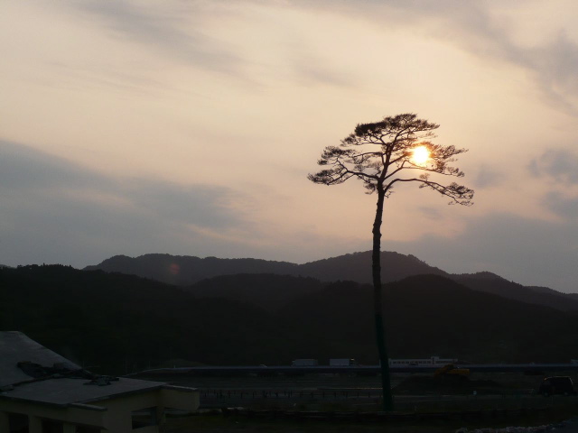
Takatamatsubara is a 2 km-long pine forest, which spread out on the bow-shaped long coast line. Hamada River runs on the east end, and Kesen River runs on the west end. The vast area of the pine forest between the two rivers had not only protected people of Rikuzentakata from strong winds, seawater, and sand, but it also served as a breakwater for over 350 years. Tree planting began around 1666. For over 10 years, because of the great efforts of two wealthy merchants and the local people, a pine forest which consisted of approximately 70, 000 black pines and read pines was grown. For a long time before the Matsubara(pine forest) exsited, Rikuzentakata was called Tatekami Beach, and it was desolated. Rice paddies and fields were buried by the sands carried in by the strong winds from the ocean. People often had poor harvests due to big waves and tsunamis. Their lives weren’t so easy. However, after the completion of Takatamatsubara, the soil became rich, and wild animals started to gather. Rikuzentakata changed from a place of desolation to a prosperous and beautiful town. Takatamatsubara had been loved by the local people as a popular place for enjoying the trees of the forest, breathing in the fresh sea-air, playing, and jogging on the beach. Over 700,000 tourists visited from outside Iwate Prefecture every year, and it had become one of the famous tourist sites in Rikuzentakta. This area had often suffered from tsunamis in the past, but Takatamatsubara endured tsunamis from both the Meiji and the Showa periods. It even survived the tsunami which travelled from the coast of Chili. However, the waves of the massive earthquake of March 11 reached over 20 meters high, and Takatamatsubara was swept away by the water. And when it was over, only a single pine tree still remained. The beautiful scenery of white sand and green pines was totally destroyed by the tsunamis. This lone pine tree was called “Hope for the Miracle Lone Pine Tree”, and became a symbol of the reconstruction. 
|